Smart Sustainable URban Flood Solutions
(SSURFS)
Usipoziba ufa, utajenga ukuta
Swahili proverb: If you do not repair the cracks on the walls, you eventually, will have to build a new wall.

Urban Flooding
If you live in an urban area, you may have experienced urban floods commonly characterized by flooded streets and low-lying urban areas. These floods develop quickly due to faster flow times over impervious surfaces. This results in loss and damage to vital infrastructure and livelihoods while the secondary effects of pollution linger long after the flood event. With weather events expected to get more extreme, the impacts will only get worse. The stormwater infrastructure in many urban areas, at present, is insufficient to deal with current and future rainfall events. The unmanaged stormwater is akin to cracks in a wall that are bound to get worse if not addressed, with the ability to paralyze activities in urban areas. A case in point is the 2021 flooding that resulted from the remnants of Hurricane Ida in New York, where up to 3 inches of rain an hour resulted in devastating flash floods in the city.
The case of Gowanus!
Authorities in New York have however been learning from previous flooding events and are implementing measures to control flooding and pollution in New York. This is best exemplified in Gowanus. Gowanus is a neighborhood in Brooklyn, New York that was recently rezoned and is set to see a lot of new development in the coming years. To protect the neighborhood from loss and damage, the neighborhood will adopt green infrastructure to control flooding and pollution. There is also a new unified stormwater rule requiring large lots to retain rainwater with technical guidelines provided in a stormwater manual.
However,
- the city notes that all the planned measures to control flooding and pollution will still be inadequate leaving 115 million gallons of Combined Sewer Overflow (CSO) unmanaged.
- Moreover, space is also limited with developers likely to maximize on real estate, leaving no room for more green infrastructure.
Smart Sustainable Urban Flood Solutions (SSURFS). A product and a service
a) The product: Smart, affordable street water flow sensors
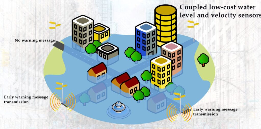
We are offering a smart, sustainable urban flood solution through the use of smart, affordable, coupled water height, water velocity, and street imaging sensors. The coupled sensors monitor water flow on selected street sections and relay early warning information where pre-determined street flows values are detected.
b) The service: Locating the smart, street water flow sensors and green infrastructure installations
In addition to the product, we are offering a service that will;
- Help in the identification of the street sections to install the smart sensors. These will be determined as street sections with significant stormwater flows. The sensors will detect the stormwater flows and transmit the information to authorities and residents within a defined geographical location.
- Help in locating green infrastructure solutions. The type, capacity, and location of green infrastructure to implement will be defined by runoff paths, as well as the quantity of excess stormwater on the streets. This will help to minimize the concentration of stormwater in flood-prone locations. Essentially, this means that instead of one or a few big installations, urban authorities and residents can put up distributed smaller installations. When considered together, these installations should manage most if not all of the stormwater upstream of the flood-prone areas.
The approach
The service solution is based on the use of Geographical Information System (GIS) technology. GIS will be applied to determine the contribution of upslope areas to the flooding experienced within the low-lying urban areas. The service solution works in the following way;
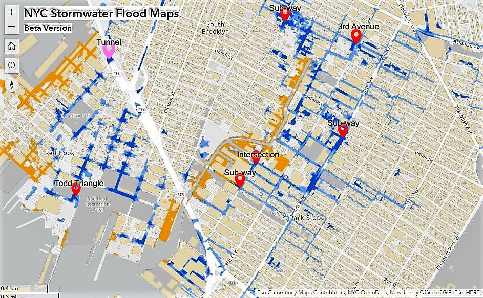
a) Mapping of flood-prone areas. Places at greater risk such as subway stations and basement apartments will be mapped.
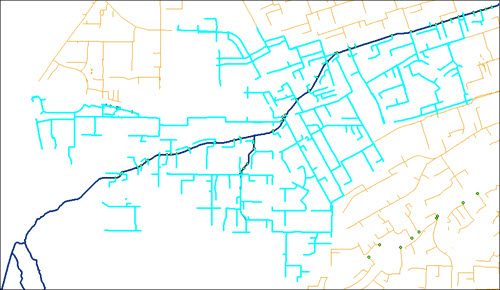
b) Next, identify the stormwater infrastructure network that would drain through the mapped flood-prone locations.
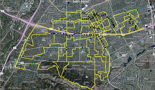
c) Sub-divide the contributing area into sub-catchments using existing drainage networks. I.e. identify different sub-catchments according to the junctions of the drainage network.

Map source: https://experience.arcgis.com/experience/7c260f80c5d44d948d45051d7a2d6d77/page/Page-1/?views=View-2. (Markers added for illustration purposes)

Source: Victor de Loza & Nahm H. Lee
Source: Victor de Loza & Nahm H. Leed) Evaluate the characteristics (geomorphology) of these sub-catchments. For example, different shapes, sizes, and drainage densities would result in different rates of flow.
e) In addition to the characteristics, we would also employ video analytics to determine the velocity of water along the streets. We will use existing footage from Closed Circuit Television (CCTV) cameras of the flooding events to detect and track objects carried by the runoff.
f) With this information, we would identify the source and volumes of stormwater runoff. We will thus be well informed on where to place our smart sensors as on the choice, capacity, and location of green stormwater infrastructure to install.
Why is the service important?
There are benefits to such an approach where sensors and green infrastructure are distributed over an entire catchment rather than concentrated in low-lying areas. The benefits include;
- Any additional infrastructure would require space for implementation which would be difficult to come by in one location e.g. low-lying areas only. A distributed approach would ensure that even smaller installations would be effective where a rainfall event is distributed.
- The volume and velocity of stormwater runoff reaching the low-lying areas are reduced enabling the existing infrastructure to comfortably convey any stormwater within it.
- Our service is complimentary to hazard mapping commonly achieved through hydrologic and hydraulic modeling. We will provide information on excess stormwater at the street level as the flood develops. Urban areas are dynamic and little developments such as putting up a flood barrier would affect the volume and rate of flow to low-lying areas. Such dynamics can be accounted for by monitoring the actual flow on the streets through smart sensors.
- Different ways of managing stormwater can be implemented at once. Depending on the location, stormwater can either be treated and reused, allowed to infiltrate, released slowly to stormwater infrastructure, etc
Who is this solution meant for?
The current solution is intended for urban authorities who are responsible for the Environmental Protection and Management of Urban areas. We have considered sustainability in the use of affordable sensors as well as through distributed smaller green stormwater installations.
We offer the following services in relation to our solution;
a) Development of low-cost sensors with the capability to measure street water elevation and velocity as well as cameras to provide visual records of urban flood events.
b) Spatial analysis to determine suitable locations for sensors and green installations. Deliverables of the analysis include a detailed report on the runoff paths and sub-catchment characteristics. We will also include recommendations on the street sections to install smart low-cost sensors as well as suitable locations for green infrastructure installations that will help to manage the stormwater runoff.
The team
We are a start-up consultancy from Kenya currently comprised of four members. We would like to connect and engage with you on smart sustainable urban flood solutions.

GIS Expert, Flood modeling
Digital Image/ video analytics
dennis.gitundu@dkut.ac.ke

Sustainable Urban
Development

Drainage system design, wastewater management

Environmental conservation and
management


